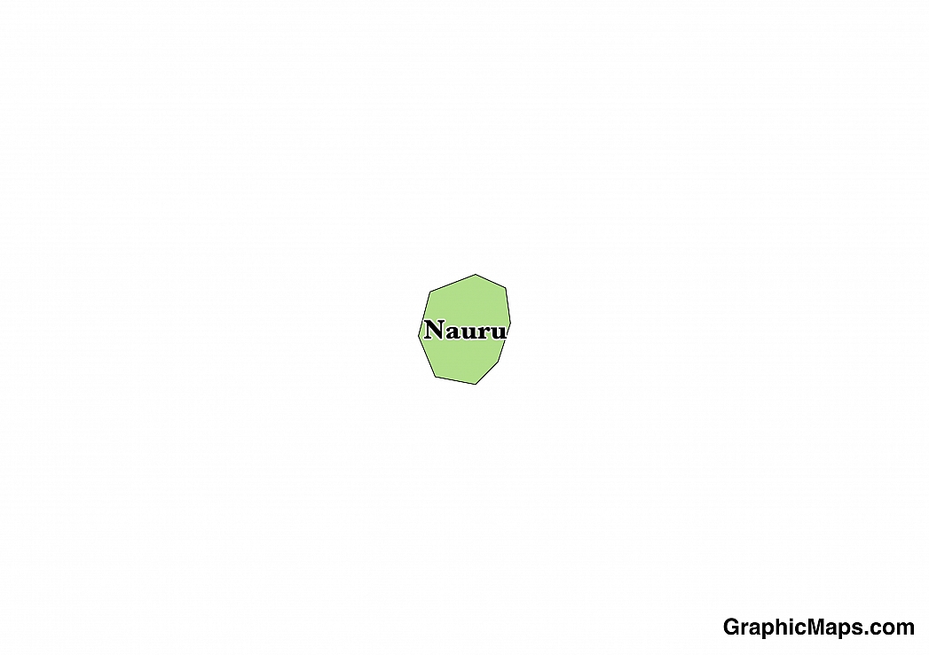
Where is Nauru?
Located in Oceania, Nauru is an island nation. It has a 30.00 km coastline.
The island nation of Nauru’s de facto capital city is Yaren which is located in the southern part of the island. Formerly known as Moqua the region was named after an important underground lake which provided much needed drinking water for the inhabitants during the turbulent years of World War II. Occupying an area of only 0.58 square miles Yaren is home to 747 people. The district has the status of being a de facto capital because Nauru has no official cities but is recognized by the United Nations as the country’s main district. The major landmark of Yaren is the Moqua Well, the underground lake for which the district is named after. Climate conditions on the island are hot and humid year round.
Read more on Nauru's CapitalNauru is an Oceanian country covering 21.00 km2. This makes it the 3rd smallest country in the world and about 0.1 times the size of Washington, DC. Its geographic coordinates are 0 32 S, 166 55 E and Yaren is the capital city.
The name Nauru comes from the Nauruan word "anaoero" which means "I go to the beach".
Its ISO code is NR.
Geography
Nauru has a mean elevation of 0 m above sea level.
It has a tropical climate with a rainy season from November to February. Its terrain consists of sandy beaches, coral reefs, and phosphate plateaus.
Population
Nauru has a population of 9,591 making it the 222nd largest in the world.
Nauruan is the most commonly spoken as well as the official language. The major ethnic groups reported are Nauruan and other Pacific Islander. The majority of the country is Protestant Christian or Roman Catholic.
The official language of the Pacific Island nation of Nauru is Nauruan. Because of the influence of a variety of other languages such as German and Kiribati this native language has evolved and changed over the years. With sixteen or seventeen consonants and twelve vowels Nauruan once included many different regional dialects but after efforts by people such as Protestant missionaries Alois Kayser and Philip Delaporte the language became standardized with far fewer local dialects. 96% of the native residents of Nauru, or about 6,000 people, speak Nauran. When touring the island a couple of useful phrases to know are, “Inga wanga daroom?’ meaning where is the room and “Imeg i anor?” which translates to “Where is the beach?” Minority languages in Nauru include English, Korean, and Cantonese.
Read more on Nauru's LanguagesThe dialing code for the country is 674.
Government
Nauru is an independent country. It gained independence in 1968 from New Zealand, Australia, and United Kingdom administered United Nations trusteeship. Its constitution was last ratified in 1968.
The Pacific island nation of the Republic of Nauru has a government which operates as a non-partisan democracy under a parliamentary republic system. Under President Hammer DeRoburt Nauru gained its independence in 1968. The country is currently lead by President Baron Waqa who took office in 2011.The business of the government takes place in the Parliament Building located in the city of Yaren. The nation’s president lives in the State House, a building which was converted from a structure previously utilized as a detention center for Australian detainees. The President and nineteen members of Nauru’s legislature are elected by the voters of nation and serve for a period of three years.
Read more on Nauru's GovernmentEconomy
Factoring in Purchasing Power Parity, Nauru's GDP is $150,800,000.00 (USD) with $14,800.00 (USD) per capita. This makes it the 221st largest economy and its citizens the 107th richest in the world. The currency of Nauru is the Dollar (AUD).
Its major imports include food, fuel, manufactures, building materials, and machinery.
Flag
Nauru is an island nation situated in the Pacific Ocean just one degree south of the Equator. Its flag serves to symbolize the country’s distinct geographical location with the color blue utilized to represent the waters of the Pacific Ocean and the yellow line bisecting the design referring to the Equator, an imaginary line which divides the planet into Northern and Southern Hemispheres. After gaining its independence a competition was held to select the country’s official flag. The winning design was publicly flown for the first time on January 31, 1968. Before that time Nauru was represented by the United Kingdom’s familiar red, white, and blue Union Jack as well as a flag representing the nation’s time under Trusteeship with Australia and the United Kingdom.
Read more on Nauru's FlagThis page was last modified on February 6th, 2018
More on Graphicmaps

Published on 2019-11-06
What is a Trade Embargo?
Published on 2019-11-04
Which Two Countries Used to Have the Same Flag?
Published on 2019-09-16
What Is the Only Two-Sided State Flag?
Published on 2019-09-16
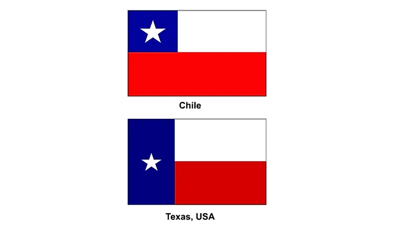
Which Country Flag Looks Like the Texas Flag?
Published on 2019-08-29
Flags That Resemble the US Flag

Published on 2019-08-20