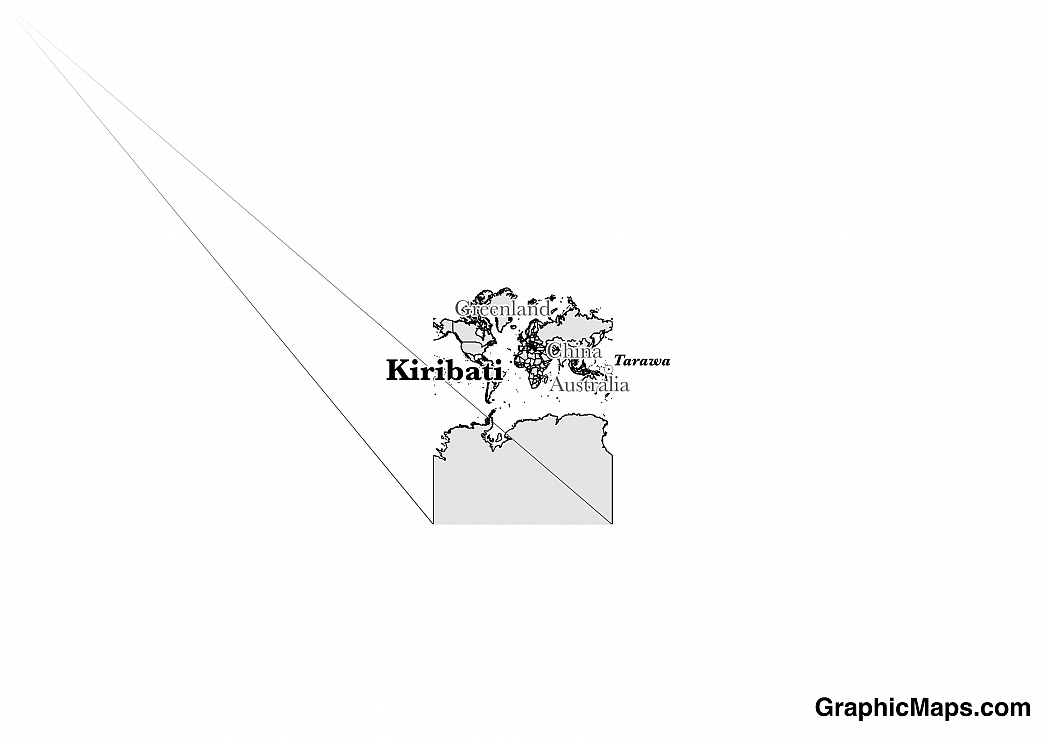
Where is Kiribati?
Located in Oceania, Kiribati is an island nation. It has a 1,143.00 km coastline.
The capital and largest city on the island nation of Kiribati is Tarawa which is an atoll which is divided into two regions; north and south. Together the region boosts a population of about 56,284 residents which is almost half of the country’s total residents. Tarawa, which lies amidst the Pacific Ocean, is believed to have been visited by its first European travelers back in 1788 with the arrival of the ship, Charlotte, and its crew captained by Thomas Gilbert. In later years Tarawa was the site of a bloody battle during World War II when Japanese forces occupied the city. Visitors to Kiribati’s capital can take in sights such as the Amboo Lagoon Club, Sacred Heart Cathedral, or Kiribati National Library and Archives. The most opportune time to travel to Tarawa is from April to August when temperatures remain fairly steady at a comfortable 86 degrees Fahrenheit.
Read more on Kiribati's CapitalKiribati is an Oceanian country covering 811.00 km2. The area includes the three island groups of Gilbert Islands, Line Islands, and Phoenix Islands which are dispersed over about 3.5 million sq km (1.35 million sq mi). This makes it the 24th smallest country in the world and about 3 times smaller than Rhode Island. Its geographic coordinates are 1 25 N, 173 00 E and Tarawa is the capital city.
The country's name comes from the local pronounciation of the word "Gilberts".
Its ISO code is KI.
Geography
Kiribati has a mean elevation of 0 m above sea level.
It has a tropical climate that is hot and humid, although it is moderated by trade winds. Its terrain mostly consists of low-lying coral atolls surrounded by extensive reefs.
Population
Kiribati has a population of 106,925 making it the 190th largest in the world.
I-Kiribati and English are both languages spoken. The major ethnic groups reported are I-Kiribati, and I-Kiribati/mized. The majority of the population identifies with Christianity.
Kiribati’s two official languages are English and Gilbertese (also known as Kirabati and Taeae ni Kiribati). The local Micronesian language has an alphabet that’s made up of ten vowels and thirteen consonants. As much as 99% of the population of Kiribati can speak Gilbertese and 97% can read it. English can be read by 80% of residents. Despite its official status English is mainly spoken in and around the capital city of Tarawa. Common words and phrases in Kiribati include the casual greeting of, “Mauri” as well as “Ti a boo” which is used to say goodbye. Minority languages in Kiribati usually originate from residents who have moved there from other nearby Polynesian islands. The ethnic group known as the Banabans originate from Banaba or Ocean Island, a very small coral piece of land which is home to less than 500 people.
Read more on Kiribati's LanguagesThe dialing code for the country is 686.
Government
Kiribati is an independent country. It gained independence from the Unied Kingdom in 1979. Its constitution was last ratified in 1979.
Kiribati’s system of government is defined as a parliamentary republic. A former British colony, Kiribati gained its political independence in 1979. The government’s executive branch consists of a president, vice president, and cabinet. The legislative branch is referred to as the House of Assembly and is made up of forty six members who serve terms of four years. The country’s House of Assembly is located in Ambo, South Taraw after being relocated from its original site in the town of Bairiki in 2000. The citizens of Kiribati participate in free and open elections which, in its most recent election, only included candidates from the Tobwaan Kiribati and Pillars of Truth political parties.
Read more on Kiribati's GovernmentEconomy
Factoring in Purchasing Power Parity, Kiribati's GDP is $211,000,000.00 (USD) with $1,800.00 (USD) per capita. This makes it the 218th largest economy and its citizens the 202nd richest in the world. The currency of Kiribati is the Dollar (AUD).
Its major imports include food, machinery and equipment, and miscellaneous manufactured goods.
Flag
The flag of the island nation of Kiribati in the Pacific Ocean includes the same features as that of its official coat of arms. With a rising sun depicted over wavy blue and white wavy lines which symbolize the ocean the flag also includes a frigatebird in flight which is located in the central portion of the design. Adopted in 1979 the flag was designed based on a badge created by Sir Arthur Grimble in 1932. The flag represents the three island groups of Gilbert, Phoenix, and the Line Islands as well as the sixteen Gilbert Islands and the former Island of Banaba. Because of its history as a British colony the former flag of Kiribati featured the British Blue Ensign along with the country’s distinctive coat of arms.
Read more on Kiribati's FlagThis page was last modified on February 6th, 2018
More on Graphicmaps
Published on 2019-11-06
What is a Trade Embargo?
Published on 2019-11-04
Which Two Countries Used to Have the Same Flag?
Published on 2019-09-16
What Is the Only Two-Sided State Flag?
Published on 2019-09-16
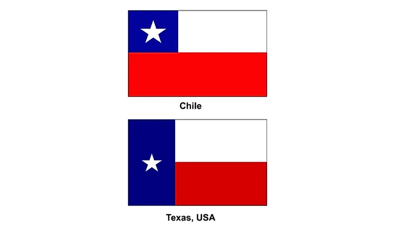
Which Country Flag Looks Like the Texas Flag?
Published on 2019-08-29
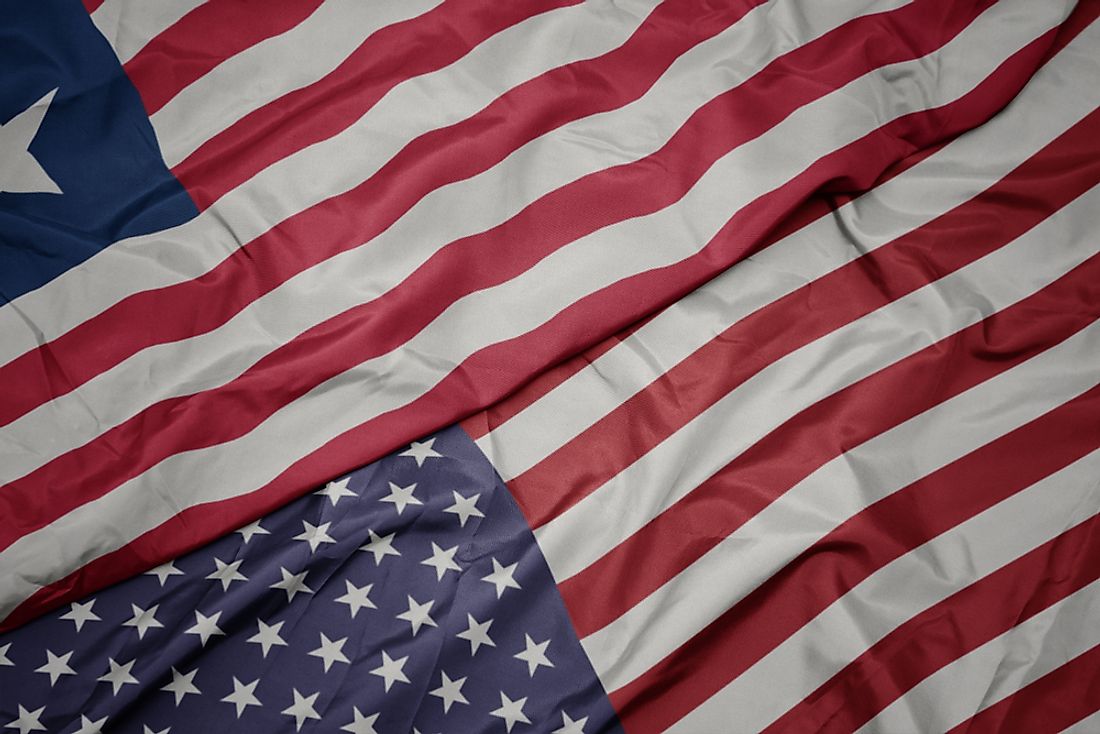
Flags That Resemble the US Flag

Published on 2019-08-20