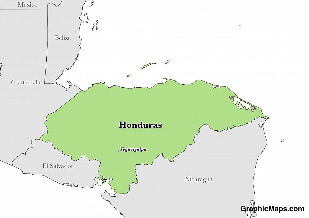
Where is Honduras?
Located in Central America, Honduras has a 1,575.00 km border with Guatemala (244 km), El Salvador (391 km) and Nicaragua (940 km). It has a 823.00 km coastline. The International Court of Justice ruled on the delimitaton of "bolsones", a disputed area along the El Salvador-Honduras border.
The city of Tegucigalpa, which is locally referred to as Teguz, is Honduras’ capital city as well as the government seat. Tegucigalpa works in conjunction with Comayaguela, its twin sister city, as a Central District thus serving as the permanent capital of the nation. Teguz became the capital city of Honduras on October 30, 1880. Tegucigalpa is the most populous and the largest city in Honduras, and it is home to 16 consulates and 25 embassies. The city had a population of 1,157,509 people in 2013, and the urban population stood at 1,055,729. The capital of Honduras has a history dating back to more than 400 years.
Read more on Honduras's CapitalHonduras is a North American country covering 112,090.00 km2 of which 0.18% is water and 111,890.00 km2 is land. This makes it the 101st largest country in the world and slightly larger than Tennessee. Its geographic coordinates are 15 00 N, 86 30 W and Tegucigalpa is the capital city.
The name Honduras means "depths" in Spanish.
Its ISO code is HN.
Geography
Honduras has a mean elevation of 684 m above sea level.
It has a subtropical climate in the lowlands which is more temperate in mountainous areas. its terrain is mostly mountainous in the interior with some narrow coastal plains.
Population
Honduras has a population of 8,893,259 making it the 93rd largest in the world. The country's population mostly resides in the mountainous western half of the country.
Spanish is the official language. The major ethnic group reported is mestizo. The majority of the country is Roman Catholics.
Honduran Spanish is the official and most widely spoken language in the Republic of Honduras. It is used in government, commerce and education. A number of Indigenous languages are also spoken in Honduras. Unfortunately, some of these languages are on the verge of extinction. The Spanish spoken in the country is heavily influenced by the local languages and is therefore distinct and unique to the region.
Read more on Honduras's LanguagesThe dialing code for the country is 504.
Government
Honduras is an independent country. It gained independence from Spain in 1821. Its constitution was last ratified in 1982.
The government of Honduras is headed by a President who is elected by citizens aged 18 years and older. The president is the head of both the government and holds executive powers. The president resides in the Palacio José Cecilio del Valle and cannot seek reelection after expiry of his four-year term. Honduras’ parliamentary building is located in the center of Tegucigalpa, the country's capital city. It houses members of the National Congress, who are elected during a general election held after every four years.
Read more on Honduras's GovernmentEconomy
Factoring in Purchasing Power Parity, Honduras's GDP is $43,190,000,000.00 (USD) with $5,300.00 (USD) per capita. This makes it the 111th largest economy and its citizens the 161st richest in the world. The currency of Honduras is the Lempira (HNL).
Its major export partners are the United States, Germany, and El Salvador. Its main exports are coffee, apparel, and shrimp. Its major import partners are the United States, China, and Guatemala. Its major imports include communications equipment, machinery and transport, industrial raw materials, and chemical products.
Flag
The flag of Honduras consists of three equal Horizontal bands of blue and white colors. The top and bottom bands of color are blue, while the center band is white. The colors in their flag represent the water bodies surrounding the country, peace, and purity of thought. The blue represents the sky above the country. Honduras adopted its flag after breaking from the United States of Central America. The five stars are a symbol of hope that the five countries that were once the Central provinces of America would one day form the union.
Read more on Honduras's FlagThis page was last modified on January 17th, 2018
More on Graphicmaps

Published on 2019-11-06
What is a Trade Embargo?
Published on 2019-11-04
Which Two Countries Used to Have the Same Flag?
Published on 2019-09-16
What Is the Only Two-Sided State Flag?
Published on 2019-09-16
Which Country Flag Looks Like the Texas Flag?

Published on 2019-08-29
Flags That Resemble the US Flag

Published on 2019-08-20