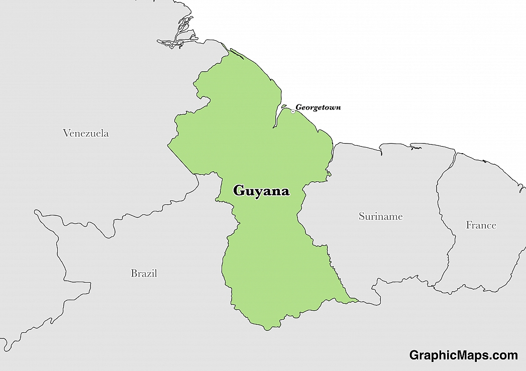
Where is Guyana?
Located in Northern South America, Guyana has a 2,933.00 km border with Brazil (1,308 km), Suriname (836 km) and Venezuela (789 km). It has a 459.00 km coastline. All of the area west of the Essequibo River is claimed by Venezuela, preventing any discussion of a maritime boundary.
Georgetown is the capital city of Guyana. It is the largest and the most populous city in the country. It is located at the mouth of Demerara River in the Demerara-Mahaica region, on the country’s coastline of Atlantic Ocean. The city initially served as the headquarters of the Demerara-Essequibo colony. It was officially recognized as the capital city of Guyana in 1782 when the French began colonizing the country. Georgetown hosts approximately 25% of the country’s total population. According to the 2012 census, the city had a population of approximately 113,368. The city’s population has however been dropping since 2012.
Read more on Guyana's CapitalGuyana is a South American country covering 214,969.00 km2 of which 8.43% is water and 196,849.00 km2 is land. This makes it the 83rd largest country in the world and slightly smaller than Idaho. Its geographic coordinates are 5 00 N, 59 00 W and Georgetown is the capital city.
The country's name is derived from Guiana, which is the original name for a region that included British Guiana, Dutch Guiana, and French Guiana.
Its ISO code is GY.
Geography
Guyana has a mean elevation of 207 m above sea level.
It has a tropical climate which is hot and humid with two rainy season from May to August and November to January. Its terrain is made up of mostly rolling highlands, with some savanna in the south.
Population
Guyana has a population of 735,909 making it the 165th largest in the world. The majority of the country's population is found in and around Georgetown.
English is the official language. The major ethnic groups reported include East Indian, black, and mixed. The majority of the country is Protestant, with significant Hindu, Roman Catholic, and Muslim minorities.
English is the official and national language of Guyana. It is the first language of most people in the country. English is an Indo-European language, which falls under the West Germanic family of languages. It uses Latin Script in its writings. The English alphabet has 26 letters with 21 consonants and 5 vowels. About 89% of the people in Guyana can fluently speak the main branch of English. The remaining people are only conversant with the Guyanese Creole, a dialect of English. Guyanese Creole slightly varies from the main branch of English in terms of sentences formation and pronunciation. They tend to repeat adverbs and adjectives for emphasis. The repetition is usually the equivalent for words such as very, too or extremely. The Guyanese Creole largely borrows from Old Dutch languages, African languages, and Arakawa languages. Other than English, there are other minority languages spoken in the country. These languages include Portuguese which is the second language to most Guyanese, Spanish, French, Chinese and Arakawa languages.
Read more on Guyana's LanguagesThe dialing code for the country is 592.
Government
Guyana is an independent country. It gained independence from the United Kingdom in 1966. Its constitution was last ratified in 1980.
Guyana is a parliamentary representative democratic state. The country’s constitution allows for a multi-party system. The president is both the head of state and government. The State House, located in Georgetown, was formerly the official residence of the Governor of British Guiana. It was constructed in 1858. The parliament building of the country is also located in Georgetown. It was constructed between 1829 and 1834. Its architectural design is the Renaissance style. Elections in the country are held after every five years. The Guyana Elections Commissions is the body responsible for conducting the elections. Members of the National Assembly are directly elected by the citizens. The parties usually have their presidential candidate. The presidential candidate from the party that garners the most number of seats in the National Assembly automatically becomes the president.
Read more on Guyana's GovernmentEconomy
Factoring in Purchasing Power Parity, Guyana's GDP is $6,051,000,000.00 (USD) with $7,900.00 (USD) per capita. This makes it the 166th largest economy and its citizens the 148th richest in the world. The currency of Guyana is the Dollar (GYD).
Its major export partners are the United States, Canada, and the United Kingdom. Its main exports are sugar, gold, bauxite, and alumina. Its major import partners are the United States, Trinidad and Tobago, and China. Its major imports include manufactures, machinery, petroleum, and food.
Flag
The flag of Guyana is commonly referred to as “The Golden Arrowhead.” It comprises of two triangles, one within the other, and depicts five colors. It consists of a green field with a red triangle bordered by black fimbriation on a golden triangle which is bordered by white. The tip of the golden triangle extends to the fly side of the flag. The flag is in the proportion of 1:2 at sea and 3:5 on land. The Golden Arrowhead was officially adopted on May 26, 1966, which is Guyana’s Independence Day. The five colors on the Guyanese flag are symbolic. The red color symbolizes the zeal and the dynamic nature of the country’s building which lies before the independent and young Guyana. Black represents the endurance that sustains the growth of the people while the golden arrow symbolizes the natural resources. White symbolizes the water and rivers of Guyana and green represents the agricultural and forested nature of Guyana. The flag of Guyana was designed by Whitney Smith, an American vexillologist. His design had no black and white fimbriations which were added following the recommendation of the College of Arms. Prior to the adoption of the current flag, the British Blue Ensign was mainly hoisted in Guyana. The ensign had a colonial badge which was changed over the years.
Read more on Guyana's FlagThis page was last modified on January 17th, 2018
More on Graphicmaps
Published on 2019-11-06
What is a Trade Embargo?
Published on 2019-11-04
Which Two Countries Used to Have the Same Flag?
Published on 2019-09-16
What Is the Only Two-Sided State Flag?
Published on 2019-09-16
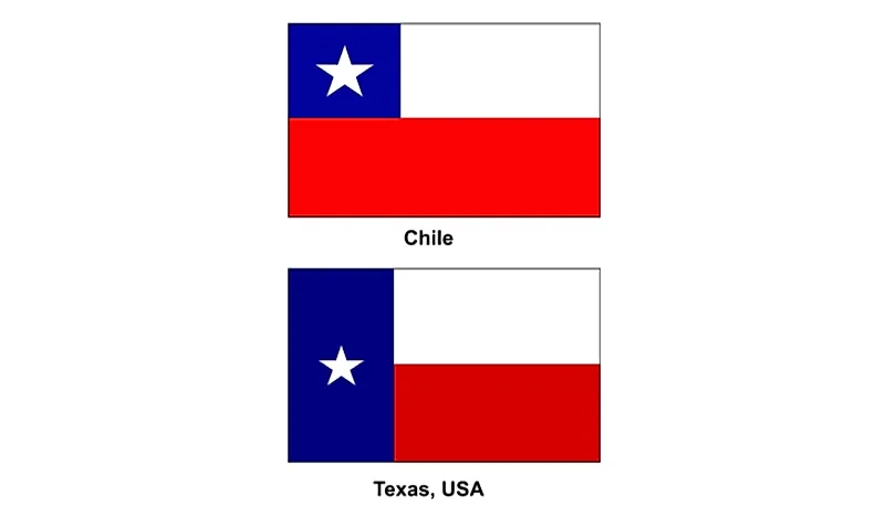
Which Country Flag Looks Like the Texas Flag?
Published on 2019-08-29
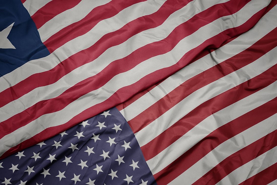
Flags That Resemble the US Flag
Published on 2019-08-20